
Mapeamento mineral em tempo real de testemunhos de sondagem com imagem hiperespectral
Na exploração mineral, decisões sobre a direção da perfuração ou sobre o desmonte precisam ser tomadas rapidamente. Atrasos nos dados mineralógicos se traduzem diretamente em custos mais altos e oportunidades perdidas. Uma caracterização mineral confiável e rápida é fundamental tanto para a pesquisa quanto para a indústria da mineração.
A análise tradicional de testemunhos consome semanas ou meses à espera dos resultados de laboratório. Ao implementar estações integradas de escaneamento de testemunhos e a tecnologia de imagem hiperespectral (HSI) — combinadas a machine learning e técnicas de fusão de dados —, os geólogos passam a gerar mapas mineralógicos e informações quantitativas em tempo real. Isso sustenta diretamente decisões mais rápidas e objetivas nos fluxos de trabalho de exploração e mineração.
Se você está perfurando agora, quer resultados enquanto está em campo — não semanas depois. Esperar custa uma fortuna. A integração hiperespectral avançada entrega informação mineralógica rápido o suficiente para impactar diretamente a decisão operacional.
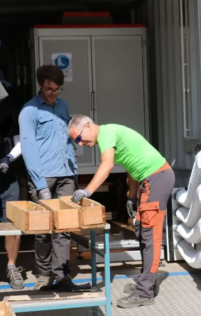
Imagem 1: Dr. Richard Gloaguen, chefe de Tecnologia de Exploração do Helmholtz Institute Freiberg for Resource Technology, inspecionando testemunhos de sondagem durante o escaneamento hiperespectral em tempo real. Imagem cedida pelo Helmholtz Institute Freiberg.
O desafio: análise de testemunhos lenta, subjetiva e fragmentada
A análise tradicional de testemunhos depende fortemente da descrição geológica manual, de medições laboratoriais e da interpretação de especialistas. Embora consolidada, essa abordagem traz limitações claras:
- Prazos longos de resposta: os resultados mineralógicos podem levar semanas ou meses para retornar de laboratórios externos.
- Interpretação subjetiva: os resultados dependem fortemente da experiência visual individual e variam de geólogo para geólogo.
- Escalabilidade limitada: é extremamente difícil aplicar uma descrição manual consistente a grandes acervos de testemunhos, com vários quilômetros de extensão.
- Conjuntos de dados desconectados: mineralogia, petrofísica e dados estruturais costumam ser analisados em silos separados.
Tanto para instituições de pesquisa quanto para empresas de mineração, essas restrições limitam o quanto os dados de testemunhos conseguem efetivamente orientar a exploração ativa e a definição imediata de alvos.
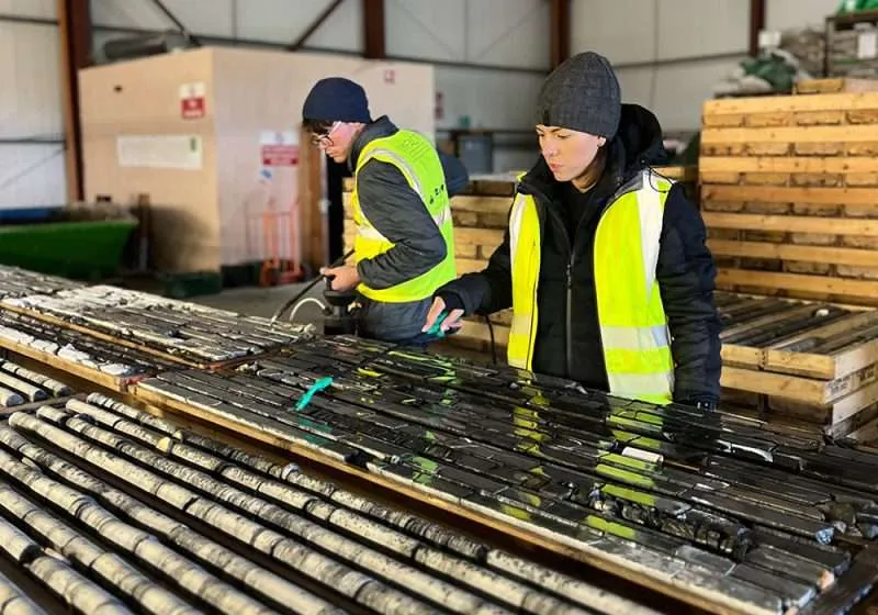
Imagem 2: Testemunhos de sondagem preparados para o escaneamento hiperespectral automatizado, como parte de um fluxo de mapeamento mineral de alta produtividade. Imagem cedida pelo Helmholtz Institute Freiberg.
Uma abordagem moderna: escaneamento hiperespectral em tempo real
Para enfrentar esses gargalos, operações de vanguarda estão implementando arranjos completos de escaneamento hiperespectral. Nossas soluções integradas de escaneamento de testemunhos fundem sensores hiperespectrais avançados com automação precisa, permitindo capturar simultaneamente informações espectrais, espaciais e estruturais ao longo de todo o testemunho.
Cobrindo toda a faixa espectral, do visível ao infravermelho de ondas curtas (VNIR a SWIR), o arranjo viabiliza a caracterização mineral detalhada em uma ampla variedade de materiais geológicos complexos.
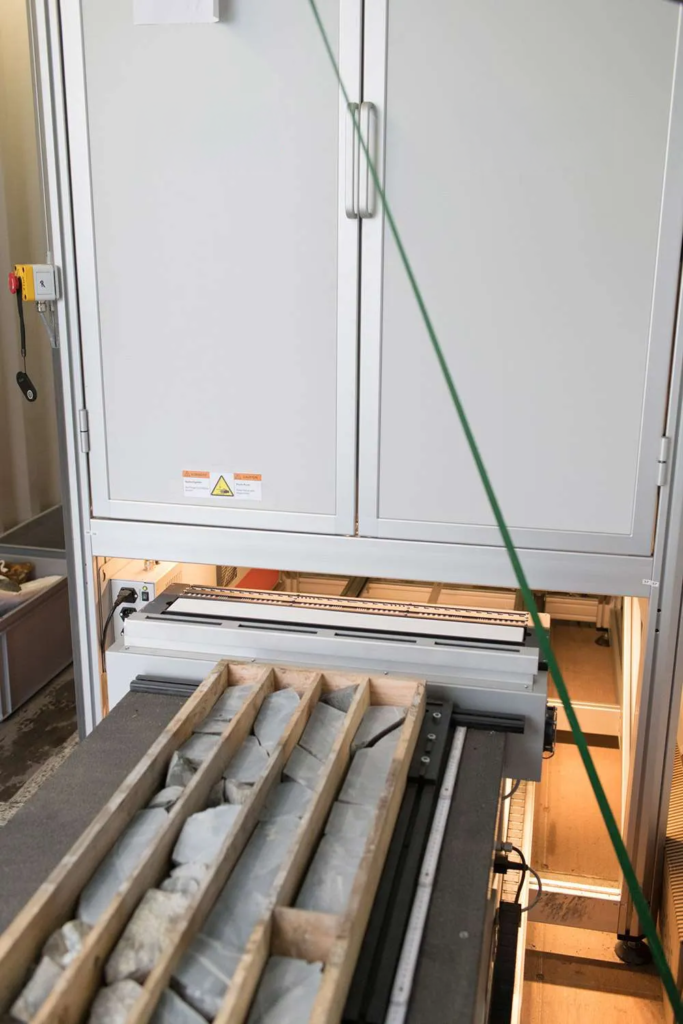
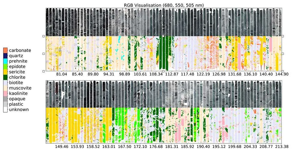
Imagem 3: Mapeamento mineral hiperespectral automatizado e análise de composição de testemunhos de sondagem. Imagem cedida pelo Helmholtz Institute Freiberg.
Fusão de dados multissensor e machine learning
Para aumentar a exatidão e a resolução dos mapas minerais, nosso fluxo de trabalho avançado integra os dados hiperespectrais a informações complementares de outros sensores. Dados de imageamento RGB, medições por XRF e microscopia eletrônica de varredura (MEV) de alta resolução podem ser combinados de forma integrada.
Essa abordagem multissensor é particularmente valiosa para detectar minerais de baixa abundância e feições de escala fina, como vênulas delgadas e halos de alteração, que são críticos para a definição de alvos exploratórios.
Para lidar com os volumes massivos de dados gerados pelo escaneamento contínuo, o sistema emprega métodos avançados de machine learning, incluindo clusterização baseada em IA e aprendizado de dicionário. Essas técnicas permitem a interpretação automatizada de associações minerais complexas e fornecem uma estimativa quantitativa rápida das abundâncias minerais.
O que resolvemos na prática: dados convertidos em ações imediatas
Outro marco importante é a eliminação da complexidade especializada dos dados. Com rotinas automatizadas customizadas e plataformas unificadas de visualização, os resultados mineralógicos podem ser inspecionados quase imediatamente após o escaneamento.
Em vez de entregar dados espectrais brutos e complexos, que exigem um especialista dedicado em hiperespectral para interpretar, nosso sistema integrado gera mapas minerais prontos para uso, codificados por cores, que podem ser aplicados diretamente por qualquer geólogo ou engenheiro de campo.
Principais benefícios do fluxo de trabalho integrado
- Mapas minerais em tempo real: retorno visual instantâneo, em vez de ciclos de semanas de análise em laboratórios externos.
- Resultados objetivos e repetíveis: geração de dados totalmente independente, reduzindo o erro humano e o viés subjetivo da descrição manual.
- Mais agilidade em campo: permite que as equipes ajustem a estratégia de perfuração em tempo real, com base em dados reais de composição.
- Redução drástica de custos: maximiza a eficiência ao filtrar quais amostras realmente exigem ensaios laboratoriais destrutivos e caros na etapa seguinte.
Dos testemunhos aos modelos geológicos 3D
Olhando adiante, o objetivo final desse fluxo unificado é alimentar modelos geológicos 3D interativos diretamente com dados hiperespectrais e multissensor. Ao identificar padrões de alteração em larga escala e “assinaturas de alteração”, os engenheiros de minas conseguem compreender melhor os processos de subsuperfície e vetorizar rumo a novos depósitos de minério de alto valor.
Ao mesmo tempo, esse sistema de alta produtividade foi projetado para maximizar o valor tanto dos testemunhos novos quanto dos históricos armazenados em acervos, garantindo que os dados antigos sejam capturados de forma consistente e permaneçam digitalmente acessíveis para projetos futuros de exploração.
Conclusão
Nossas soluções unificadas de imagem hiperespectral oferecem uma resposta prática e de nível industrial a um dos desafios mais críticos da exploração mineral: o tempo. O sistema entrega confiabilidade em toda a faixa espectral, sustentando a transição da pesquisa científica complexa para a aplicação prática e de alta eficiência no chão de fábrica ou na mina em operação.
Ao combinar calibração otimizada de sensores, pipelines robustos de machine learning e automação industrial resistente, ajudamos você a destravar o verdadeiro valor dos seus dados geológicos, transformando meses de espera em sucesso operacional em tempo real.